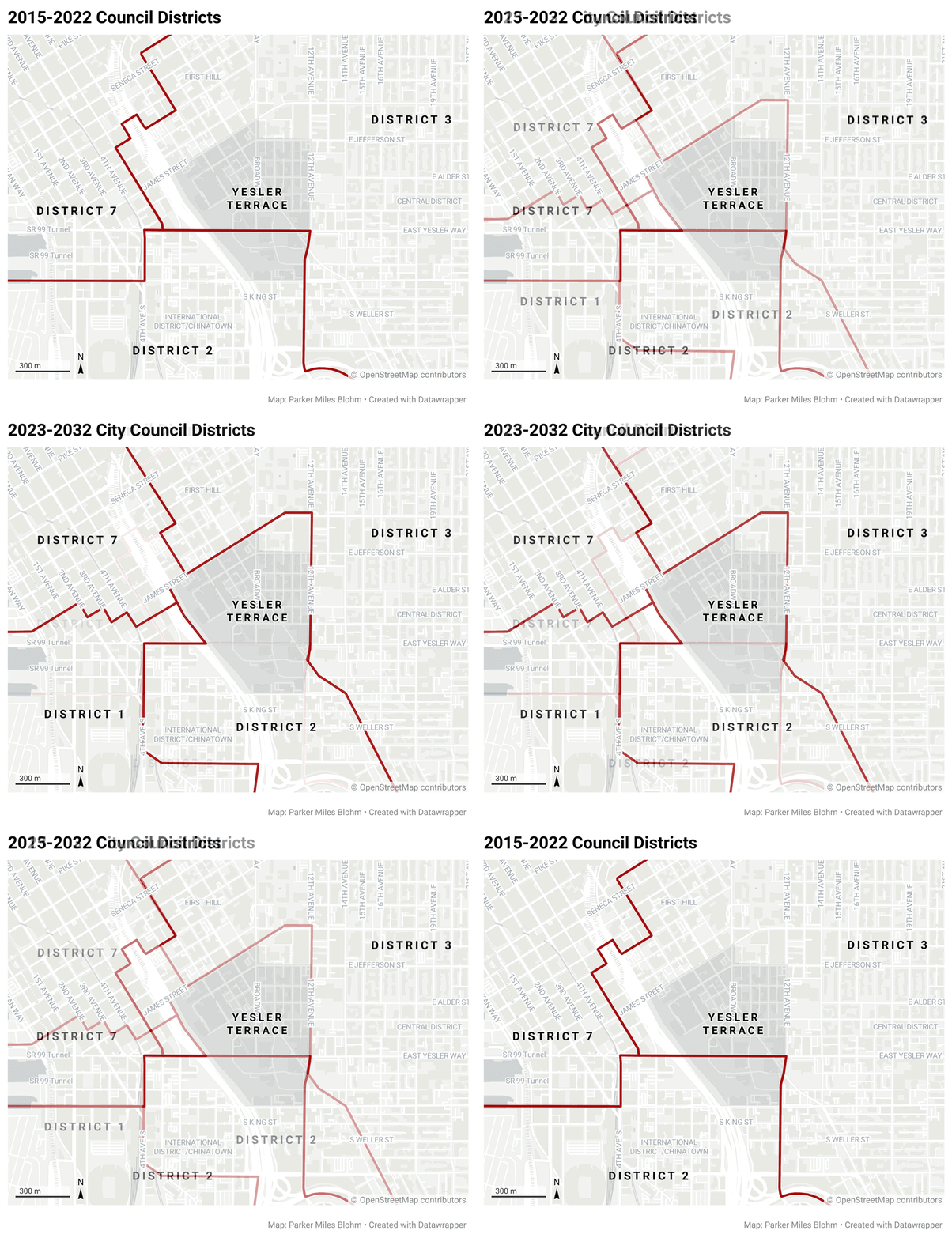
Yesler Way — a steep, busy street that early Seattle lumberjacks used to skid logs down into Elliott Bay — physically splits the Yesler Terrace neighborhood in half. But for years, it’s also been a political boundary between two Seattle city council districts.
"When it comes time for an election, you have people that are going out to their neighborhood and they're saying, 'hey, let's come together and vote for this person, let's vote for this issue,'" said Jude Ahmed, who works down the street at the Urban League, a social services nonprofit that advocates for Black communities.
"But then they start to realize — 'oh, there's a line dividing us.' So on the other side of the street, people have totally different candidates on their ballot."
In 2021, following the 2020 U.S. Census, Washington state re-drew its Congressional districts. Last year, cities and counties in Washington re-drew their political boundaries too – and in 2023, local elections will take place under those new maps.
The maps can shift the balance of power between neighborhoods simply by splitting some neighborhoods up – and bringing others together.
To Ahmed and other advocates, neighborhoods like Yesler Terrace have been drowned out for years.
Yesler Terrace was named after its public housing complex – the first in the state, and the first racially integrated one in the nation. But that project has been dismantled and is being replaced by denser private development, much of which is supposed to be affordable.
Between the construction and the three hospitals within a mile, it's a loud neighborhood.
NiRae Petty moved to Yesler Terrace after college because it felt like a vestige of the Central District she remembers. Once a majority Black neighborhood, the Central District where Petty grew up is now a majority white.
"A lot of people are still here. Their families are still here," Petty said. "They still go to the same community center. And it's almost like, just because we've got a streetcar and a coffee shop and we see goldendoodles walking around, does it mean that, you know, people aren't still here?"
Petty took a job at Urban League too. But a few months ago, she moved across town when her rent got too high.
At some point last year, Petty and Ahmed realized the lines that divided Yesler Terrace were being redrawn.

Usually redistricting is a process Republicans and Democrats do, sometimes behind closed doors – like in Washington state in 2021, a process so un-transparent it drew lawsuits.
Seattle’s redistricting process was supposed to be better. It was also a first for the city, since Seattle voters decided to move to a district system just 10 years ago. This map drawing was nonpartisan, and basically all done out in public.
"They're making the map right there in front of the cameras," said Dave Bradlee, a software programmer. "I'm like, 'that's really cool. That’s what I’d like to see more of.'"
Bradlee is a former Microsoft programmer who designed an app that allows you to draw your own redistricting maps. He named it Dave’s Redistricting App, without really thinking about it, because he never thought it would be big.
"I don't know, maybe I was eating like Dave's Killer Bread or something like that, you know?" he said.
But governments and advocacy groups around the country have used it. Seattle’s redistricting commission even used it, and they let the public submit their own maps using Dave's Redistricting App.
The final map put Yesler Terrace where Petty and Ahmed wanted it. Not just all together, but in the same district as the South End, Seattle’s only city council district that’s a majority people of color.
To do that, the redistricting commission picked a map that split a different neighborhood to the north – Magnolia. It’s a quieter, whiter and wealthier neighborhood dominated by single-family homes, though it’s also changing.
A Magnolia resident who identified himself as Pat Kraft spoke out against the change during a public comment period.
"Dividing us in any way is... well, it's offensive for who we are and who we want to be," Kraft said.
Former Seattle mayor Greg Nickels was the only member of the five-person commission to vote against the final map.
"I tried to express this towards the end of of it: good process, but it was a bad product, in my opinion," Nickels said.
Nickels, app designer Bradlee, and others proposed maps that didn’t split Yesler or Magnolia. But the redistricting commission didn’t pick those.
NiRae Petty's stance: It would be great if we could keep every neighborhood together.
"We know why you don't want to be split. Like, we know why because we don't want to be split," Petty said.
But every map the commission seriously considered split some neighborhood in some way. It's unavoidable in the current system, which requires the city be split in seven equally-populated parts.
So Petty would rather make sure the people who are the most marginalized – the most under threat – stay together.


